< Back to A level Cheat Sheets
A Level Geography
⚠ This is a work in progress, unfinished document. The most unfinished sections are marked with [tbd] and there may be general issues and typos. ⚠
please let me know if there are any errors :)
Latest update: 19/08/2023 11:06.
Last content addition: 07/07/2023 23:16.35
Use a PC/device with a large screen to see the Table of Contents on the left-hand side to quickly navigate through this document.
Discuss with other students, developers, educators and professionals in the Baguette Brigaders Discord server! You can also receive a notification when there are new things added!
Top notch graphic design by me
For more information, see the end.
1.1 Option B – Glaciated Landscapes
“Feeling a little like a drumlin today.”
Check out this interactive ARCGIS British ice map to see places in the UK which have been influenced by glacial activity, with drumlins, subglacial lineations, moraines and more!
Glaciers as Systems
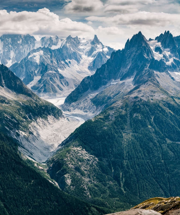
Photo from Simon Fitall
There are 3 main parts to any system: inputs, processes and outputs.
Glaciers are dynamic. Glaciated landscapes may be seen as a system with many interrelated components (stores), processes (cause/effect mechanisms) and inputs outputs. This forms an open system.
- Inputs
- percipitation (snowfall)
- material from deposition, weathering and mass movement
- avalanches
- thermal energy (from sun)
- kinetic energy
- Outputs (Ablation)
- evaporation
- sublimation
- wind erosion
- meltwater
- Stores
- ice
- water
- debris
- potential energy (from its location)
- Throughputs/processes
- debris movement down slope
- deposition
- kinetic energy from glacier movement
Glaciers themselves can be seen as systems as they have a TON of different inputs, and outputs, flows (or transfers) and stores.
Useful key terms
- Terminus - the end of a glacier
- Snout - the end area of a glacier
- Ablation - melting
- Calving - when chunks of a glacier terminus fall into water
- Advance - when a glacier is moving forwards; gaining mass balance
- Recession - when a glacier is retreating; losing mass balance
- Area of accumulation - the area of a glacier where it is gaining mass
- Area of ablation/wastage - the area of a glacier where it loses mass
- Névé - young, granular snow
- Firn - névé which has survived a full season (year) of ablation and is partially compacted, and has been recrystallised into a substance denser than névé, an intermediate stage to becoming glacial ice.
- Firn line/equilibrium line - the zone on a glacier where accumulation is equal to ablation over a 1-year period
- Sintering - continued fusion and removal of air as a result of compression by the continued accumulation of snow and ice
- Aspect - the direction that a slope faces.
- Azimuth - the compass direction of an object
The Glacial Budget and Mass Balance
A glacier forms when snowfall exceeds summer melt in an area, resulting in the accumulation of snow and ice year after year, typically in a hollow on a mountain with a northwest-southeast aspect in the northern hemisphere.
Over time, snow is compacted and turned into glacial ice, and when this is around 40m thick, the intense pressure causes it to begin flowinghe top of the glacier is white, but glacial ice at the base of the glacier is blue as oxygen has left the system.
Snowflakes -> Granular snow -> Névé -> Firn -> Glacial ice
Glacial ice has a density of 850kg/m3. It is rock hard and feels glassy and is almost translucent.
The glacier mass balance is the total sum of all the accumulation (snow, ice, freezing rain) and melt or ice loss (from calving icebergs, melting, sublimation) across the entire glacier, or ablation.
Over a year, the graph of mass balance in a northern hemisphere glacier may look like this in an ideal scenario:
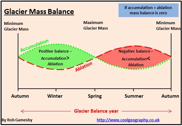
An equilibrium is reached between accumulation and ablation are equal. This point may be reached between the accumulation extreme in winter, and ablation extreme in the summer season.
Layers of snow within the ice give evidence for the way that it has formed.
Types of glacier and movement
(Date studied: ~29/09/2022)
An ice sheet is a mass of snow and ice, greater than 50,000km2 with considerable thickness.
A piedmont glacier is one that spreads out as a wide lobe as it enters a wider plain typically from a smaller valley
A valley glacier is one bound by valley walls, coming from higher mountain, from a plateau on an ice cap or an ice sheet.
Ice cap - a dome-shaped mass of glacial ice usually situated on a highland area and also covers >50,000km2.
Valley glaciers usually occur in high altitude locations, with high relief, and have fast rates of flow at 20–200m/year and have distinct areas of ablation and accumulation, descending from mountains.
Ice sheets however, are large masses of snow and ice defined by being greater than 50,000 km² and are usually in locations of a high/low latitude and have slow rates of movement and only around 5m/year. The base of the glacier is frozen to the bedrock and have a little precipitation but also lower temperatures so ablation levels are lower too.
Fundamentally, glaciers move because of gravity. The gradient influences the effect of gravity on glaciers. Thickness of the ice, and the pressure exerted on the bedrock can also influence melting and movement. More accumulation also leads to more movement. When ice is solid and rigid, it breaks into crevasses (big gaps visible from the surface). Under pressure, ice will deform and behave like plastic (zone of Plastic Flow on the lower half of the glacier) making it move faster . Conversely, . The rigid zone is on the top half of the glacier.
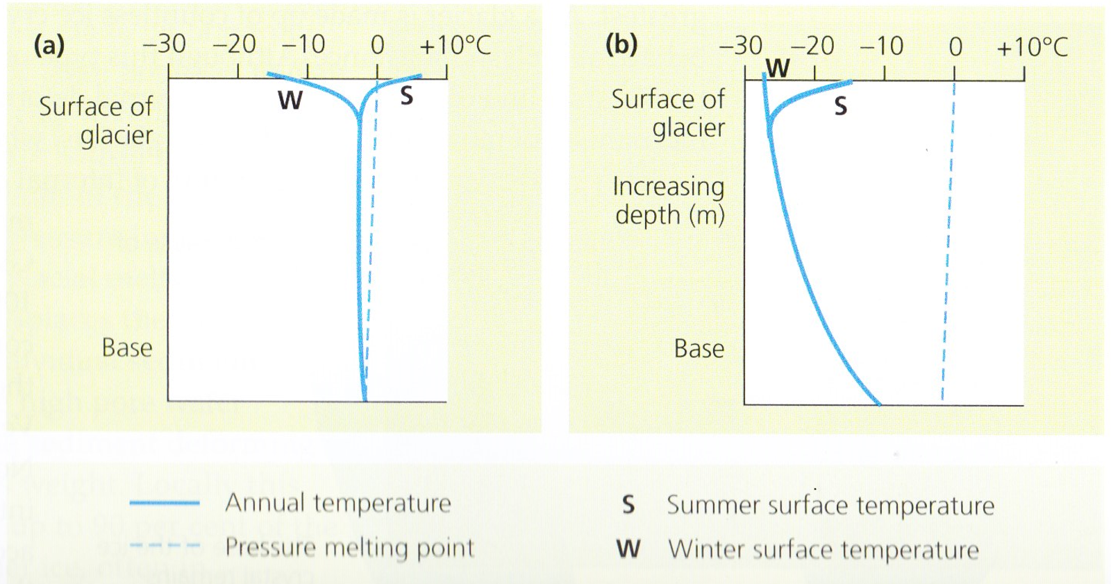
Cold-based glaciers:
- have a slow rate of movement (<5m/year);
- are located in extreme latitude (polar) regions;
- are flat in general;
- have a low basal temperature, remaining stuck to bedrock below the pressure melting point;
- are in low precipitation areas and the glacier remains below freezing point.
Warm-based glaciers:
- have rapid movement (20-200m/year);
- are located in high altitude (mountainous) regions;
- have a basal temperature at or above pressure melting point;
- have steep relief;
- have water present throughout, with ice acting as a lubricant.
Cold-based glaciers are unable to move by basal sliding as the basal temperature is below the pressure melting point. Instead, they move through internal deformation, and ice at 0°C deforms 100 times faster than at -20°C.
[tbd] Useful stuff
- Supraglacial material is material which is located on the top of a glacier.
- Englacial material is material which is located inside a glacier.
- Subglacial material is material which is located on the base of a glacier.
- Material deposited during glaciation is called drift.
- Material deposited directly by ice is called till
- Material deposited by meltwater is called outwash, or glacio-fluvial material.
Lodgement till is material deposited by advancing ice, due to pressure being exerted into existing valley material, and left behind as ice advances, such as drumlins.
Ablation till is material deposited at the terminus by melting ice from stagnant, or retreating glaciers during a warm period or end of glaciation event. Most depositional landforms are this type.
It can be known whether sediment was deposited by water or ice. Ice-transported sediment is angular, not curved, as it has not been subject to erosional forces by the meltwater. The order of size of sediments can indicate this too, as water deposits sediment progressively due to reducing energy levels, while glaciers deposit material unsorted and ‘en masse’. Glaciers deposit till in mounds and ridges too, as, during ablation, this englacial and supraglacial material gets dropped on the bedrock below. This is distinct from the layered deposition (or strata) typically characterised by fluvioglacial processes.
Factors affecting the microclimate
Regional climate
The wind is a moving force and is able to carry out processes such as traglaciers deposit material unsortd erosion. In the air, these are known as aeolian processes, and can contribute to shaping glaciated landscapes.
The wind is a moving force and is able to carry out processes such as transportation, position and erosion. In the air, these are known as n processes, and contributes to shaping glaciated landscapes.
Wind is more effective when acting upon fine materials, usually those previously deposited by ice or meltwater, such as smaller rocks, dirt and sand.
Temperature within the climate is another factor, as temperatures above 0°C will melt accumulated snow and ice, resulting in more outputs in the system. At higher altitudes, there are typically more prolonged periods of above freezing temperatures, and melting, compared to in high latitude locations, where is below freezing most of the time, allowing for glaciers to thicken and expaensive ice sheets to form. Precipitation is another climate factor, with its totals and patterns, both regionally and seasonally, in determining mass balance of a glacier system, as it provides the main inputs to these glaciers as snowfall.
Geology
Lithology is the chemical composition and physical properties of rocks. Some types, like basalt, are very resistant to erosion and weathering, as they are comprised of densely packed interlocking crystals. Clay, on the other hand, is weak, and does not have these strong bonds on the molecular level. The solubility of rocks like chalk can also be affected by acidity, making them prone to chemical weathering as seen, through carbonation.
Structure relates to the physical rock types, like faulting, bedding and jointing. These all have an impact on how permeable rocks are. Chalk, for example, is very porous, spaces between the particles within it on the molecular level allow water to percolate through. Some types of limestone, like carboniferous limestone, has many interconnected joints, giving it ‘secondary permeability’.
Primary permeability is when spaces brackets (pores) absorb and retain water.
Latitude and Altitude
Beyond the Arctic and Antarctic circles, located at 66.5° north and south, the climate is very dry, with a little seasonal variation. Being so dry and extremely cold, they are much different to valley glaciers, which are more dynamic, as they have higher precipitation levels névé turns into firn. The dryness contributes to periglacial environments (see below for more about those!) while also turning the types of glaciers in these areas to more cold-based. This means that they flow much less quickly, and different types of movement occurs.
Altitude also has a direct impact on the temperatures and development of valley glaciers. As temperatures typically decrease by 0.7oC every 100m of altitude gained, there are more likely to be valley glaciers in areas of high relief, as seen in the Alps and in the Himalayas. These glaciers are still not as cold as cold-based glaciers however.
How are glacial landscaped developed?
Glacial landforms are typically classified according to erosional and depositional processes, however they can also developed through a series of interrelated processes.
Glacial erosional landforms
Corries
A corrie is an armchair-shaped depression in a mountain.
Also known as a cwm or cirque, corries are formed from small hollows on the slopes of mountains where snow begins to accumulate, typically on the north-west to south- east facing slopes (or with an azimuth ranging from 300-140 degrees) sof a mountain in the northern hemisphere.
This is due to its aspect, or the orientation of which a slope faces, with this specific aspect resulting, having less time in the sSun, which adds thermal energy to the system and results in ablation.
Over time, this virgin snow, orinto ice and névé, turns into firn after one complete cycle without melting. Over multiple years, the snow at the bottom is compressed into ice, and plucking begins to be the dominant process. This newly-formed hollow, deepened by nivation. This hollow, deepened by nivation, is the free with freeze thaw and material is removed by meltwater. This then moves because of gravity on the ice mass. The ice freezes to the back wall, plucking material (debris), which is then. This is washed out through a process known as rotational slumping.
When this ice melts, a tarn, or corrie lake, is created, with potentially a lip madea rock lip from moraine or rocks forming at its front. Material may then fall down from the back wall due to its aspect and steep relief, which is known as scree,
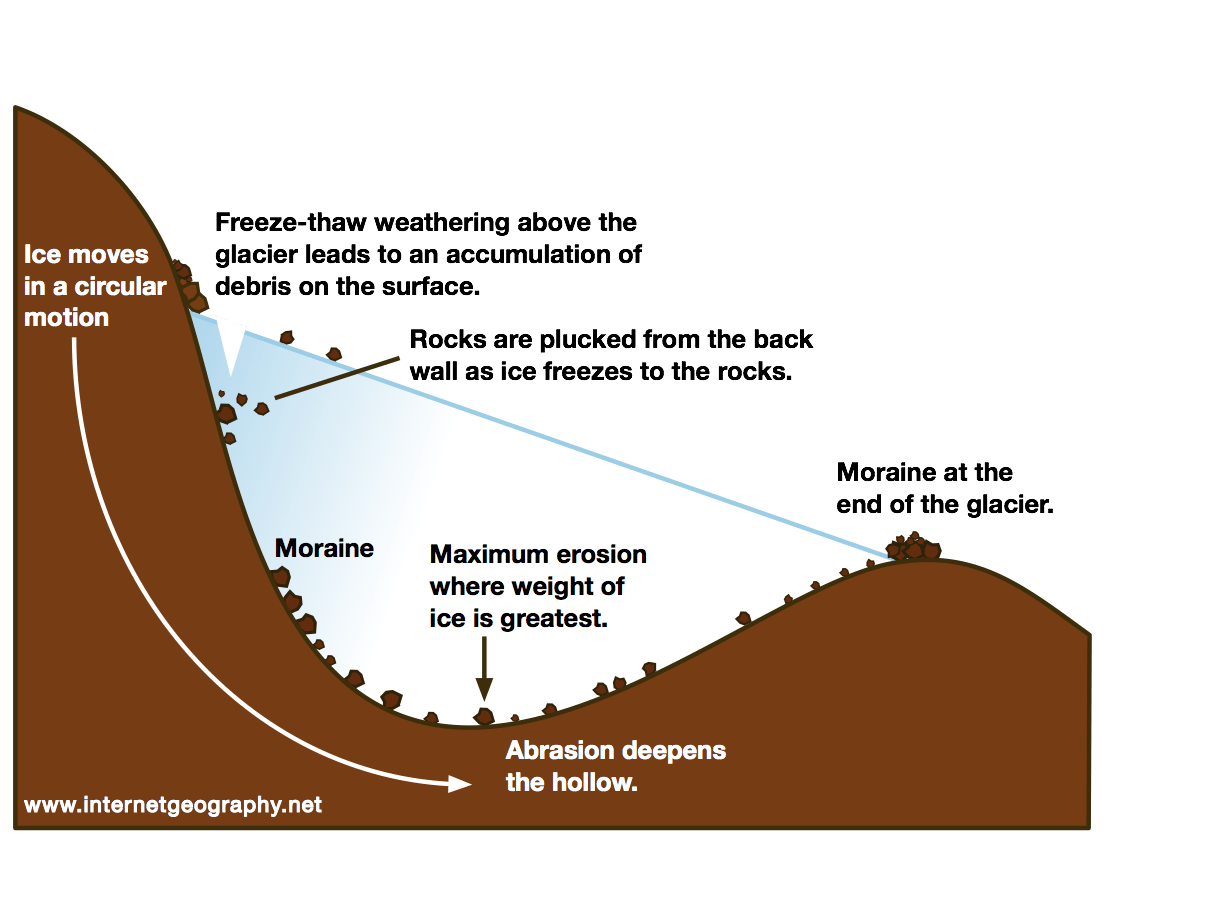 loose material.
Arêtes
An arête is a knife-shaped sharp ridge formed when two corries’ back walls continually erode back-to-back. Over time, these back walls meet, and a distinct ridge is formed.
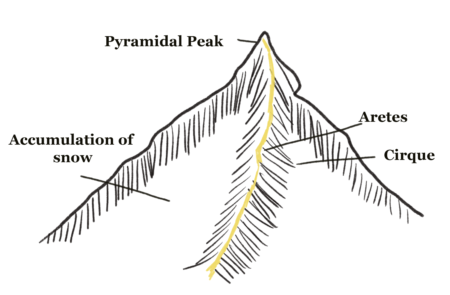
Pyramidal peaks
A pyramidal peak is a high mountain whose surrounding have been eroded from corries. Three or more corries eroding back-to-back (similarly to how arêtes form) results in this sharp peak forming.
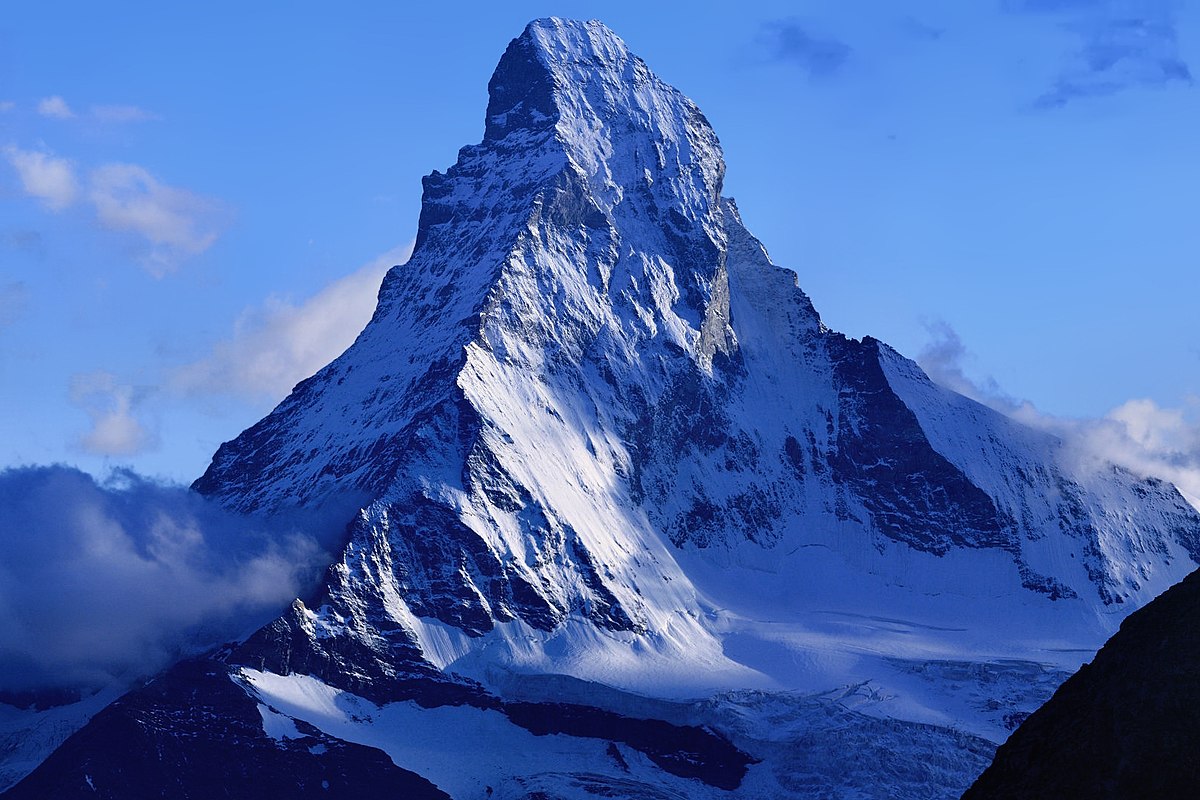
The Matterhorn in the European Alps. It is a great example of a pyramidal peak.
U-shaped valleys
A glacial trough or U-shaped valley is a result of strongly channelled ice, with plucking from a valley’s sides causing them to steepen.
Firstly, a V-shaped valley has steep sides and a central river channel, with interlocking spurs being a distinct feature. During periods of glaciation, snow begins to accumulate in these valleys as they are often sheltered.

When an ice mass has formed in the valley, fFreeze-thaw weathering begins occur above the glacier line, causing the valley to steepen, in the same way as a corrie steepens its back wall. The glacier itself also causes plucking, mostly on the sides, as rocks are frozen and ripped as the glacier moves. Abrasion also deepens the valley floor as subglacial material comes into contact with the bedrock.
Hanging valleys with waterfalls and truncated spurs are a feature of this landform. A ribbon lake/loch as well as a misfit stream may also be present in the base of the newly-formed glacial trough valley.
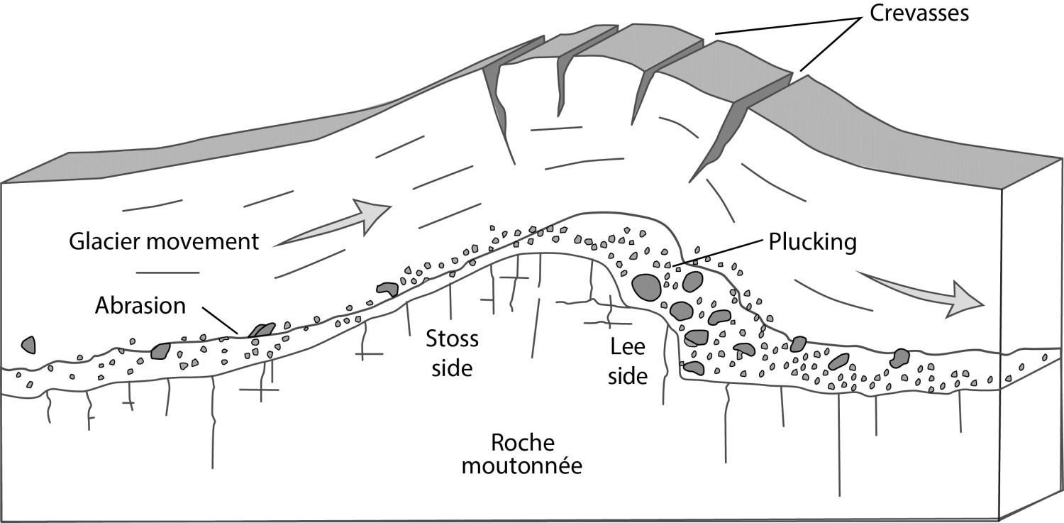
Roche moutonnées
A roche moutonnée is a more resistant rock in the path of a glacier. AIs abrasion occurs on the upvalley (stoss) side, resulting in striations, grooves, and polishing from subglacial debris… As meltwater is forced up and over the roche moutonnée, plucking and freeze-thaw weathering occurs. O on the downvalley (lee) side, as pressure release results in refreezing, while the glacier continues to move, pulling away the rock.
Roche moutonnées are generally concentrated in areas of competent bedrock such as granitoids (Glasser, 2002).
Source: Québec government website https://gq.mines.gouv.qc.ca/lexique-stratigraphique/quaternaire/roche-moutonnee/
The word is French with roche meaning rock and moutonée meaning sheep.
More specifically, it was introduced by a French geologist called Horace-Bénédict de Saussure (1740-1799). The word is called like so due to its resemblance to the shape of a wig worn by 18th century French aristocrats which shaped their hair like a wave. Sheep fat was used to hold the wig in place, which explains the term moutonné (Benn and Evans, 2010). In Sweden, very large roches moutonnées are called flyggbergs, with some being up to 3 km long and 350 m wide (Rudberg, 1954; 1973; Iverson et al., 1995; Benn and Evans, 2010).
(Epically translated by me, you’re welcome.) [2]
[tbd] Glacial depositional landforms
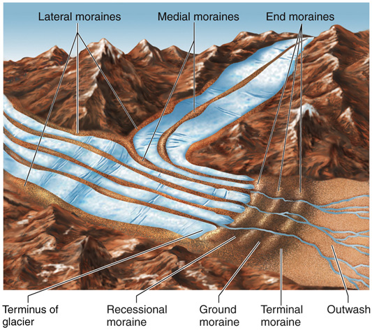
Moraines
Moraines are ridges of soil, rocks and till which has been deposited by a glacial system.
Medial moraines - in the centre of a glacial channel
Lateral moraines - at the side of a glacial channel
End moraines - marking a halt of glacial retreat
Terminal moraine - a larger ridge marking the maximum advance of a glacial period (glacial maximum).
Recessional moraine - just the end and terminal moraines
[tbd] Erratics
They are randomly placed bits of rock and other debris which can be characterised by being of a different rock type than surrounding rocks, e.g limestone in a valley mainly of basalt.
This can be seen in the Lake District where rocks belonging to the rock group Borrowdale Volcanics were found in an area dominated by limestone.
Drumlins
Drumlins are streamlined till, commonly elongated parallel to the former direction of ice flow, composed of glacial debris, and sometimes having a bedrock core which formed beneath an actively flowing glacier. They typically occur in larger groups, or ‘swarms’. This is known as a ‘basket of eggs’ topography.
Ribbon lakes
Ribbon lakes are both depositional and erosional. They are formed by the combined processes of glacial erosion, which deepens and widens the valley floor, and glacial deposition, which leaves sediment along the shores of the lake. The glacial erosion creates the U-shaped valley that eventually becomes the lake, and the glacial deposition creates the lake’s shoreline and bottom. These lakes are typically long, thin and deep as a result of compressing flow, as this ice is likely to have come from an area of high incline to a more expansive area. This means that the ice is more likely to move faster and pushed into a thinner area downstream, so is more likely to erode vertically rather than laterally. More detail over at the ullswater case study.
[tbd] Case study: Lake District
[Dev Note] 02/02/2023: Just need to add examples from the essay as well as some research info.

Glacial features of the Lake District, including subglacial lineations, meltwater channels, eskers, drumlins, moraines, glacially streamlined bedrock and more.
Glenridding Valley & Ullswater
Ice from Red Tarn at Helvellyn flowed north-east into Glenridding Valley. As a result, a glacial trough was created in Ullswater, a long, thin, deep ribbon lake as a result of compressing flow with the ice mass moving fast and thinner downstream, so was more likely to erode vertically. This glacier would have continued flowing downstream towards modern-day Penrith, which is in a flat plains area, possibly resulting in the old Ullswater glacier becoming a Piedmont glacier on entering this large valley expanse. Inside modern day Ullswater is a series of roche moutonées such as Norfolk Island and Lingy Holm. The rock is more resistant than other types, resulting in striation lines with the freeze-thaw weathering being visible on the lee side still today.

The Glenridding village has visible depositional till extending into Ullswater, visible from satellite imagery, easily proving that there was once glacial activity in the area.

As you can see, there is material extending into Ullswater from the valley leading down from Helvellyn. This shows that there was substantial amounts of debris that was being deposited and moved along this glacial route.
Essay snippet: inter-related valley landforms [16 marks]
A corrie, or cirque, is formed by snow falling and compacting in a hollow over many winters, typically on the northern side of mountains in the northern hemisphere due to the sheltered aspect. Over time, snow accumulates, compacting the snow beneath it into ice due to the air being displaced. The back wall on the mountain, in this example Helvellyn in the Lake District, gets increasingly steep due to persistent freeze-thaw weathering and plucking of material entering the young glacier as englacial material, or landing on the surface as sub-glacial material. At the same time, under its own weight, the ice at the base begins to rotate, known as rotational slipping, deepening the base through abrasion, with this abrasive material being finer sub-glacial debris. At Helvellyn, the bedrock type is known as the Borrowdale Volcanics, having formed 450 million years ago and moved from tectonic forces. Despite this relative strength, several corries have formed and melted during the Pleistocene period. After the most recent glaciation period known as the Loch Lomond Stadial around 12,000 years ago, there exists a corrie containing red tarn on Helvellyn’s north-easterly terrain. These corries have eroded back to back, resulting in the formation of a reeds, knife-shaped ridges, namely striding edge and swirl edge. Furthermore, red tarn has a lip, preventing water loss, as a result of rock or moraine deposits. These examples show that landforms in a valley glacier system are significantly interrelated between different erosional landforms as the quarry is responsible for the creation of many other landforms during and after when glaciation has occurred.
[tbd] Ice Sheet Case Study: Minnesota & Lake Agassiz

The Laurentide Ice Sheet during various glacial stages
[Dev Note] 02/02/2023: Add lobes.
Lake Agassiz was a vast glacial lake located in central north America which was fed by contributory meltwater from the Laurentide ice sheet, which was up to 2 miles in height in some places. It was larger than every Great Lake combined, covering around 300,000 square kilometres, around the same size as the Black Sea.
When an outburst flood occurred, around 11,000 years ago, it resulted in large scale erosion of an area 8km wide and 76m deep in Browns Valley, Minnesota. This old river is known as the Glacial River ‘Warren’. It helped form the modern Minnesota and Mississippi rivers.
Its major drainage reorganization events greatly had an impact on climate, sea level and possibly even early human civilization.
The erosion and the melting formed the glacial river warren and formed the modern Minnesota and upper Mississippi rivers.

The top left is the bed of Lake Agassiz, and the eroded area is visible too. North Minnesota.
AN interactive map of glacial extent and lobes is available here.
Wadena lobe
The Wadena Lobe had depositional impacts on the north-west of the state. Its deposits were red and sandy, derived from red sandstone & shale rock in the north and the north-east of Canada.
It first deposited the Alexandra moraine, which resulted in drumlin swarms over three counties including the Wadena county itself as well as Otter Tail and Todd counties.
It also deposited the Itasca moraine series which has similar features.
At its glacial maximum, it reached just south of Minneapolis.
Rainy and Superior lobes
The rainy lobe moved in after the Wadena lobe in the same general area, but only covered half the area. However, the Superior lobe was much larger and moved in from the north-east. It partly covered the modern-day Lake Superior, on the east side of the state.
Their last glacial advance deposited coarse till which contained various types of basalt, gabbro, granite, red sandstone, slate and even greenstone. The red sandstone made the overall deposits seem reddish and dusty-looking.
Deposits can be found across the north-east half of Minnesota, stretching as far south as Minneapolis.
Like Wadena, it too deposited drumlins.
Des Moines lobe
Moved in from the north west, covering vast expanses of the west of the county from the most northerly point to the most southerly point. It deposited till that is tan to buff coloured and is clay rich and calcareous due to its shale and limestone source in the north east.
In the south west, Prairie Coteau is an example of a terminal moraine.
Many of its deposits are over 160 metres deep.
Erosional impacts of the ice
The highest mountains in Minnesota are worn down so they’re now just 500 to 700 meters high. A large ellipsoidal basin was created and contains thousands of lakes like Upper and Lower Red Lake in North Minnesota, and Mille Lacs Lake in Central Minnesota. In the Arrowhead Northeast region this was deep due to earlier tectonic tilting of the landscape which exposed weak shale rock. Lakes here lie in deeply eroded shales.
Deglaciation
Glacial Lake Agassiz was formed by glaciers which blocked the natural drainage of the area and as a result a lake developed to the south of the ice. The river that drained Lake Agassiz was known as Glacier River Warren. This left behind fertile silt deposits in what is now the Red River Valley.
The water is then thought to have overflowed at Brown’s Valley and cut the present Minnesota River Valley, described as a glof, a glacial lake outburst flood. This discharge was staggering and also helped form the adjacent Mississippi River.
Post-glacial modification
The present landscape of Minnesota resulted largely from glacial activity in the Quaternary Period, or the most recent 2 million years. The Laurentide Ice Sheet grew and retreated several times over this period. Isostatic readjustment occurs when glaciers ablate due to the land not being under pressure anymore. This land then typically rebounds upwards and elevations increase in the area where glaciers once lay. Fluvial activities continued to mould the landscape after full glacial retreat had occurred.
Glacio-fluvial landforms
(Date studied: 23/11/2022)
Glacio-fluvial means an environment shaped by glacial meltwater.
Geomorphic means changes (morph) to the land (geo).
Drumlins
Drumlins are streamlined hills, commonly elongated, parallel to the former direction of ice flow, composed of glacial debris, and sometimes having a bedrock core formed beneath an actively flowing glacier. They typically occur in larger groups, or ‘swarms’.
Eskers
Eskers are long sinuous (having many curves and turns) ridges made from sand, gravel and other types of glacial till deposited on valley floors by glacial meltwater flowing through subglacial and englacial tunnels, as well as through supraglacial channels.
Elongated ridges of glaciofluvial sediment deposited in subglacial meltwater pipes
These tunnels and channels over time become filled up with sediment. During deglaciation, this sediment is dropped onto the bedrock, leaving ridges, signifying that a glacial tunnel was somewhere above it.
Some argue that deposition is caused when pressure is released at the glacier’s snout, so as the glacier retreats, the point of deposition retreats too. This can describe their beaded appearance (vary in height and width throughout) with the beads of greater size representing periods of relative slow retreat or halted ablation. Others may say that the larger beads are caused as a result of greater load carried in the summer meltwater.

Here’s 2 angles showing what they look like, in Svalbard.
The weight of the ice above the subglacial tunnels mean that the water flowing is under extremely high pressure. When the ice melts, this pressure is released, so therefore dropping sediment. Eskers can be deposited, ignorant of local topography, meaning that they can traverse over hills in the landscape.
The path taken by this pressurised meltwater is mostly controlled by the slope, size and direction of the ice surface rather than the bedrock. Because of this, eskers can be used to show the slope of the ice surface and its extend. It also runs parallel to the direction of ice flow, and therefore transverse to the glacial snout.

Eskers on paleo-ice-sheet beds are more abundant in areas of crystalline bedrock with thin coverings of surficial sediment than in areas of thick deformable sediment, because meltwater flowing at the bed is more likely to incise upwards into the ice to form an R-channel where the bed is hard; where the bed is deformable, meltwater is more likely to incise downwards.
You don’t need to remember that.
Examples
Many eskers are found in central Ireland, some are in Canada, as well as many in Iceland and Sweden.
Here is an example of an esker on Google Maps.
A meltwater stream is visible south of it, as well as another esker to the east.
Post glacial climate change in Eskers
During periods of increasing global climatic temperatures, the rate of glacial ablation increases and results in more meltwater being produced. This means that there is more accumulation of sediment in proglacial areas and the length of these eskers is likely to increase, or become more beaded with greater and more intense ablation periods.
Kames and kame terraces
A kame is an irregularly shaped hill, hummock or mound made of stratified glacial till comprised of mainly sand and gravel.
There are two types of kame:
Delta kames
Delta kames can form in two main ways. Firstly, they can form due to the build up of debris in englacial tunnels that emerge at the glacial terminus ass a result of retreat. As a result, they lose their energy, and are forced to deposit their contained load.
Another way that they can be formed is when supraglacial streams meet ice-marginal lakes. These ice margin water bodies are largely static (just sit there tbh) so the sediment they carry loses energy and gets deposited in the lake, from where this supraglacial stream enters it, often leading to a tall accumulation.
Kame terraces
Kame terraces are ridges of material near or on the valley margin. They are largely comprised of ex-lateral moraine, which was transported into the ice marginal lake due from the supraglacial streams formed due to the warming of ice through friction with valley walls. As this is largely glacio-fluvial, unlike morainic deposits, these are somewhat sorted and stratified by the movement of water. When the glacier retreats, this sediment is dropped and collapses onto the bedrock floor.
Watch out! Many people say ‘kame’ when they mean ‘esker’! You need to know the differences between the two well. (main one is eskers are subglacial, kames are not)
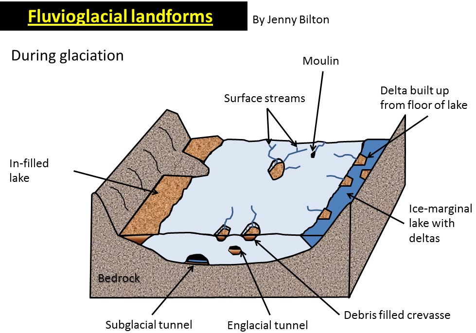
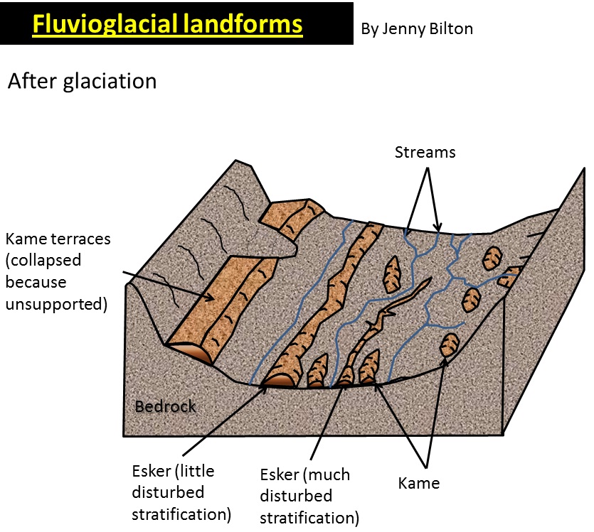
This displays the distinction between kame and esker.
As climate change increases temperature levels, more meltwater is present, which transports and deposits sediment. This will result in a larger amount of all types of kame being more likely to form.
Here is an example of an esker on Google Maps: https://www.google.com/maps/cheatsheet-esker-link
A meltwater stream is visible south of it, as well as another esker to the east.
Essay example: influence of climate changes and geomorphic processes in their formation
Kames are are mounds of sediment deposited by glacial meltwater or ice, found in areas where glacial ice melted and receded, leaving behind sediment deposits. The process of kame formation is complex, and is a result of a variety of interrelated factors, including climate change and geomorphic processes.
Climate change is one of the most significant influences on the formation of kames. During the Pleistocene epoch, large areas of the northern hemisphere were covered in thick glaciers. As the climate warmed and the glaciers receded, large volumes of meltwater were released, carrying sediment with it. The sediment was deposited in stratified piles, forming these kames, visible in places in the UK such as the Scottish Highlands or the Lake District. This can be proven to be the result of a glacio-fluvial deposition as they are deposited in one go by melting ice, while previous meltwater surface stream moved the sediment into crevasses or glacial marginal lakes.
Geomorphic processes also play a role in the formation of kames. As the glacier erodes the landscape, valley sides’ sediment may fall onto the glacier, ranging from large boulders to sand grains. The size and shape of these kames varies depending on the type of sediment deposited, as well as the rate of erosion. In addition to erosion other geomorphic processes can play a role in the formation of kames such as weathering. These processes such as frost-shattering and chemical weathering can break down sediment particles and form smaller particles that can be easily carried by wind or water. This can cause further accumulation of sediment in certain areas and contribute to the formation of kames. Lithification may also occur when the sediment is compacted and cemented together, forming a solid mass among the trapped sediment.
In conclusion, climate change and geomorphic processes are both important factors in the formation of kames. Climate change causes the glaciers to melt, releasing large volumes of sediment, which is then deposited in strata. Geomorphic processes, such as erosion, sedimentation, and lithification, also contribute to the formation of kames. Together, these two factors contribute significantly to the formation kames, alongside many other factors like the topography, aspect and relief of the local region.
Proglacial lakes
Proglacial lakes form in front of glaciers, usually when meltwater streams become blocked by terminal moraines, glacial dams (trapped against a large ice sheet) or due to isostatic depression of the lithosphere into the weaker asthenosphere.
The meltwater, over time, accumulates in this area, unable to flow outwards. This is similar to how a traditional valley glacier system starts with the corrie melting and a tarn being left due to a terminal moraine blockage.
After a glaciation period, the climate typically warms up. Over time, if there is a large ice sheet blocking the water flow, this sheet will ablate, and the lake will either overflow or undermine the dam, causing a glacial lake outburst flood, or jökulhlaup.
Modern example: The Russell Fjord in Alaska is regularly blocked by the Hubbard Glacier, which can increase water levels in the fjord by up to 15m as it cannot empty out into Disenchantment Bay: Google Maps/3D Google Earth.
Outwash plains
Outwash plains are also known as sandurs. They are dominated by other landforms, including braided streams and kettles. They occur in front of melting glaciers, and are mostly flat and expansive areas. Meltwater traversing this terrain has little energy, and therefore little vertical erosional power and more inclined to deposit material. As a result, these flat areas are created from stratified (strata; layered) sediment.
As the glacier moves over bedrock, plucking and abrasion (erosion) occurs resulting in silt and sediment being carried in this meltwater. Braided streams are dominant in outwash plains. These are very shallow streams and rivulets which carry and redeposit till due to the little energy in the system.
In summer months, there is typically higher glacial discharge and ablation, resulting in these tilly islets being destroyed by water, which has a little more energy due to increased velocity. This leads to more erosion, and these islets then go on to reform later. This makes the outwash plain have a distinct look. This can be described as dynamic.
The elevated level of erosion is typically closer to the glacial snout but then progressively loses energy.

In areas that were once glaciated, old outwash pains can be found by looking for sediment, with large angular rocks and boulders being present closer to the glacial mass and smaller, smoother rocks and sediment being further away from the glacier, similarly to a typical river system aside from their origin. Outwash plains can extend for miles beyond the glacial margin (terminal moraine).
Braided streams
The general consensus is that braided rivers form instead of meandering rivers due to a higher sediment load, caused by discharge from ablation, as well as variable rates of flow.
At the end of a melting period, these lose water, lowering kinetic energy present in the system and therefore losing erosional power and increasing depositional power.
This results in material being deposited into the river channel, causing it to divide in two. Braiding itself develops when this ‘mid-channel bar’ grows downstream, as a result of more, finer material being added to the bar as discharge amounts continue to decrease. These bars, during times of exceptionally low discharge like in winter months, may become home to vegetation, becoming even more permanent. whereas unvegetated bars are less stable and often move with high discharge.
Many of these channels branch from other channels and merge to give it the ‘braided’ pattern. They are common in outwash plains due to the variable nature of ablation and meltwater amounts.

diagram of a braided stream
They are found in large quantities in south Iceland, for example.
Due to climate change, braided streams may dry up due to smaller amounts of ice present in these areas, after an initial increase in ablation due to temperature rise. This initial increased sediment load will progressively decrease as the ice mass decreases.
As a result, there can be expected to be more eroded streams, being deeper and wider, inside this outwash plain, followed then by the area becoming dry and tundra-like. Whilst vegetation thrives in outwash plains due to the rich minerals present in the glacial meltwater, this may also dry up in the future, becoming a barren, sandy and gravelly area with little life, or could be taken over and reclaimed by plants depending on resource availability.
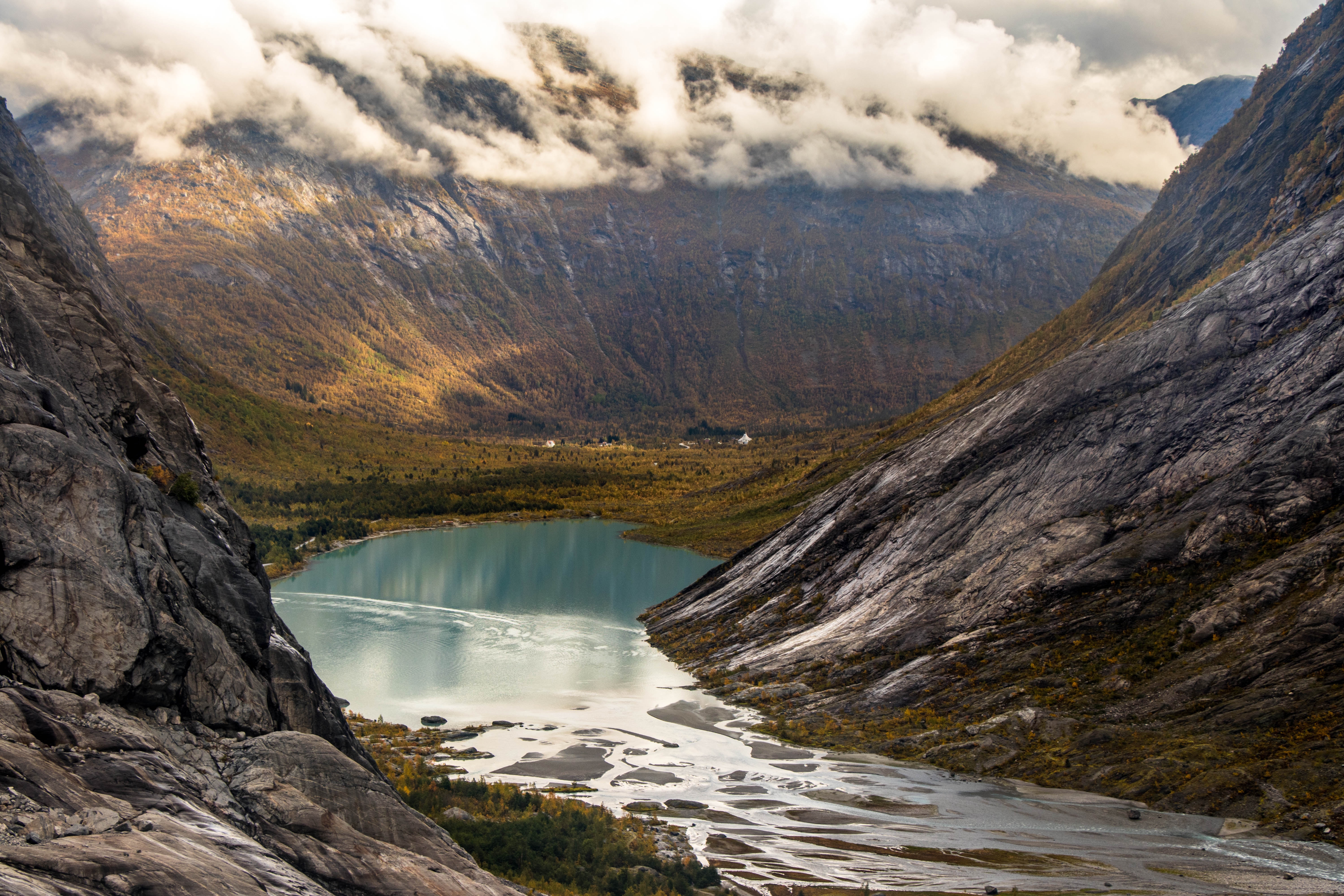
Is that a braided stream AND a proglacial lake inside a valley glacier system?
Photo from Jonas Mendes.
Kettles
A kettle is a large depression in the ground formed by glacial deposition, and is therefore a depositional landform. They create ‘dimples’ in the landscape around mountainous areas.
They are formed by large blocks of ice breaking from the main glacier. As the main glacier retreats, this ‘dead’ ice becomes stranded and, over time, becomes buried by sediment deposits as meltwater flows around it from the main glacier. Of course, this ice melts and its water evaporates, leaving behind a large depression, or kettle holes. Water can then fill these in again, or if not all water drains originally, resulting in kettle lakes.
Periglacial landforms
Periglacial landforms exist as a result of climate changes before and/or after glacial periods.
Periglaciation is concerned with the process and landforms attributed to the action of permafrost.
Being in a periglacial area means an area that is near to, or on the fringe of, glacial areas’ ice mass. This means that there is no physical glacier system present in the area, but it is still cold, relative to surrounding environments.
Permafrost
This is also part of the Earth’s cryosphere, as well as glaciers, ice sheets, and more!
Permafrost itself is comprised of:
- the active layer (this is the top few metres or so. It is warmer as it is closer to the surface. It may become unfrozen during the summer months and vegetation may grow too.)
- the permafrost layer itself.
- talik (year-round sections of unfrozen ground, soil, rocks that lies in permafrost areas, but itself is not frozen)
There are 3 types of permafrost:
- Continuous permafrost: there is little thawing, even in the summer. These are often in areas of high altitude and latitude.
- Discontinuous permafrost: There are some patches of consistent permaforst, but are broken up by talik extending to the active layer
- Sporadic permafrost: small amounts of permafrost largely enclosed by talik
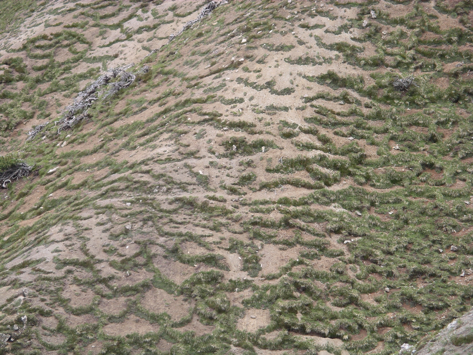
Patterned ground
This encapsulates sorted stone polygons, stone stripes, etc.
These landforms are facilitated the process of frost heave. Stones within the ground and active layer have a lower specific heat capacity, allowing them to cool down and heat up faster than their surrounding soil. Due to the freezing conditions, water below the stones freeze as well, and also expanding by 9%, pushing the stones upwards. Over time and many years potentially, the stones are pushed to the surface, and to a larger extent, the frost heave sorts all fine and larger material too, creating a domed surface! How exciting.
Stones which are on top of this dome then fall down to undomed areas because of gravity. This is typically every 1 to 3 metres. These rows of stones can end up connecting and form polygonal shapes.
On slopes, between 3 and 50 degrees, these polygons become warped and are known as elongated stone polygons, or garlands. On even steeper terrain these become stone stripes.
Blockfields
Lord help me if this comes up in the exam (iam not religious)
Blockfields are believed to be formed as a result of chemical and mechanical weathering below the active layer in periglacial regions such as plateaus or mountain tops, as these are typically glacial fringe regions rather than ice covered areas.
Over time, these processes produce an uneven, angular & bouldery landscape which is only revealed after the permafrost layer melts away, forming ‘in situ’ (alternatively by rock glaciers - which are glaciers containing a large amount of frost-shattered rocks.). Blockfields potentially formed 23 million years ago during the Neogene epoch, when the climate was relatively warmer than today; higher amounts of chemical weathering then initiated the (very slow) process of eroding formed bedrock.
Resistant rock, or tor, may be more prominent in these blockfields as they are not as susceptible to denudation (erosional processes).
On slopes above a gradient of 25o, block streams/stripes are formed as gravitational forces will move this material down a slope.
Types of mass movement
Solifluction lobes
When the ground and soil on slopes is frozen during the winter, the soil particles are separated slightly and loosened by the ice which forms and expands by around 9% between these particles (frost heaving).
During the thawing of the active layer in the spring and summer months, water saturates the ground as it cannot drain easily (due to the impermeable, frozen permafrost below - it is forced to stay in the upper layer) or evaporate due to the cooler climate. Friction is reduced between these particles, which are already loose due after the freezing months, as this water is able to lubricate them. As a result of this excessive lubrication, the soil moves downslope easily. (The extra mass from the water can also help with this.)
Soil/Frost Creep or Mass Wasting
This is a process which moves material down a slope by a few centimetres per year even on high gradients.
On freezing, the particles in the slope’s soil are raised at a 90o angle to the slope (vertically), and when the soil thaws and the particles are dropped, the particles are now at a slightly lower point to their original location. This is then repeated over time
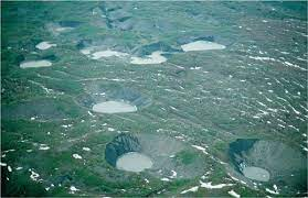
Pingos
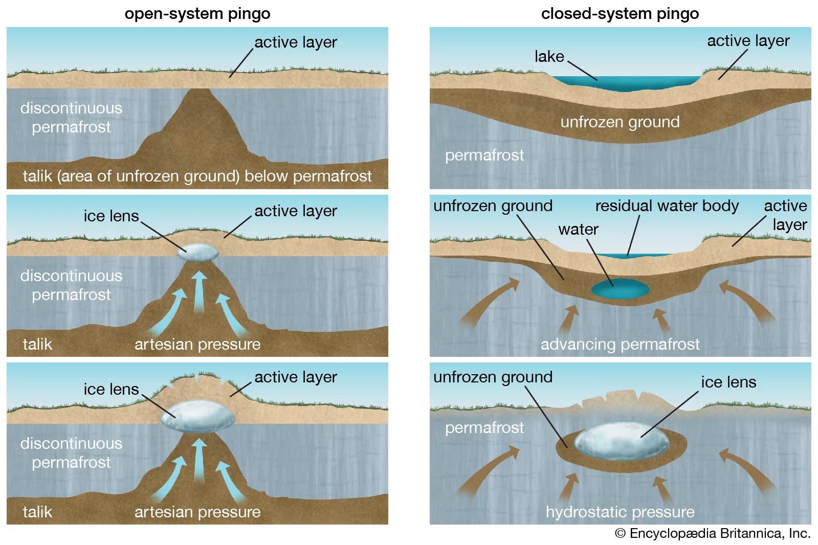
Open system, hydraulic
These are also known as East Greenland type pingos as they commonly occur there.
They form in areas of discontinuous permafrost, typically in the base of valleys. Groundwater collects in the bottom of the valley, and begins to freeze and expand under artesian pressure, creating an ice lens between the active layer and the discontinuous permafrost. This ice lens creates a dome, expanding the ground and active layer upwards.
Closed system, hydrostatic
These are also known as MacKensie type pingos.
These pingos develop below lakes, due to the immediate water supply. Lake water enters the talik as it is trapped between the frozen surface above and permafrost advancing during cooler periods. The talik becomes saturated quickly and hydrostatic pressure compresses this as much as possible, forcing out any warmer air bubbles. Due to the persistence of permafrost, it forces this saturated talik to freeze, becoming an ice lens, and expanding upwards into the familiar dome we know, love and recognise as a pingo.
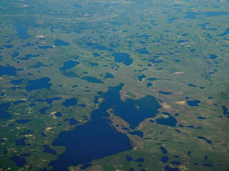
Bonus! The ice lens can collapse and leave a depression, typically a marshy area called an ognip, surrounded by ramparts.
Ice-wedge polygons
Soil cracks when cooled quickly, just like how mud cracks when dried.
In summer, this crack in the soil fills with meltwater. Over time as many freeze-thaw cycles occur, the ice is expanded by 9% each time. This eventually results in the formation of an ice wedge. Each time the water is refrozen into ice, pressure against the surrounding soil increases, causing it to be pushed upwards, contributing to the development of these polygonal features.
Summary: Soil cracks when cooled quickly. In summer the crack fills with meltwater, and as it refreezes many freeze-thaw events take place, expanding the ice by 9% each time. This eventually results in the formation of an ice wedge.
Human activities in Periglacial Landscapes
Key Ideas
4.a. Human activity causes change within periglacial landscape systems.
4.b. Human activity causes change within glaciated landscape systems.
Case study: Oil extraction in Alaska (Periglacial)Alaska - Periglacial Landscapes
Part of Alaska is located within the arctic circle, at 66.5oN.
However, since 1968, vast amounts of oil reserves have been found offshore and within Alaska itself, including inside the ANWR (Arctic National Wildlife Refuge) and, more specifically, Area 1002the 1002 Area within it. An estimated 12 billion barrels of oil is located in this area alone, with half of it (~6bn) being available to extract using currently available techniques.
For the United States, this would provide a key resource for energy security, while at the same time reducing dependence on foreign, potentially malicious, entities, which may limit their supply, such as Russia. This weakness has been seen in Europe, with Russia’s invasion of Ukraine, so now more than ever the US sees this as essential.
It imported 37% of its total oil consumption in 2016 (7,259,000 barrels per day).
Hydrological processes
Gravel extraction adds insult to injury. The loss of gravel from fluvial systems can change the composition of the river profile and exacerbate damages further downstream from the extraction site. Extracting gravel from a glacial outwash site has been proven to lower the groundwater levels by over a metre in a 2km radius as well.
Urban heat island effect
Barrow, Alaska is the northernmost settlement in the USA and the largest native community in the Arctic, with a population of 4600 in 2000, increasing from just 300 in 1900. Recent decades have seen an increase in mean annual and winter air temperature, with an earlier snowmelt in the village and a
weaker snowmelt trend in the surrounding tundra.
The urban heat island (UHI) effect is a phenomenon where urban areas are significantly warmer than their rural surroundings due to activities by humans, like air conditioning, hot water pipes and road building.
A strong urban heat island (UHI) was found during winter, with the urban area averaging 2.2 °C warmer than the hinterland. There was a strong positive correlation between monthly UHI magnitude and natural gas production/use, ultimately resulting in a 9% reduction in accumulated freezing degree days in the urban area.
This excess heat is mostly generated from:
- The burning of fossil fuels during flaring. This increases the carbon dioxide concentration in the local atmosphere, resulting in an enhanced greenhouse effect. This increases amounts of terrestrial radiation within these areas.
- The absorption of solar radiation by urban surfaces - solar insulation warms up these more than surroundings as tarmac/gravel structures are black, which absorb more radiation.
- The reduced evaporative cooling from vegetation.
As a result of this input imbalance, permafrost can thaw, leading to changes in the landscape and the release of trapped carbon dioxide and methane, which can further contribute to climatic changes in these areas locally, as well as internationally, as permafrost contains 1.5 trillion metric tons of carbon (that’s 1,500 petagrams if you’re fancy like that - or double than what’s in the atmosphere today).
This thawing can furthermore lead to infrastructure damage, as roads and buildings can be damaged by the shifting of the ground due to solifluction.
Thermokarst
A landscape characterised by depressions due to the thawing of the ground ice which comprises the active layer and permafrost below. Visible in the Atlaskan North Slope.
Case study: Kárahnúkar HEP Dam, Iceland
This dam (or, collection of three dams) were built in East Iceland on a large proglacial lake, sourced from one of the largest glaciers in Europe. It is actively retreating, so provides water to the dam which can then be used as hydroelectricity. The dam itself was finished in 2007 and is large enough to be seen from space.
The dam could provide enough energy for all Icelandic homes and small businesses, but instead all energy provides the nearby aluminium smelter called Alcoa.
However, there has been widespread backlash over the prokect, as it flooded over 400,000 acres of unspoilt highland wilderness which was the second largest unspoiled area in Europe. In total, almost 750,000 acres of land was affected by the construction of the dam, which is around 3% of Iceland’s total land mass.
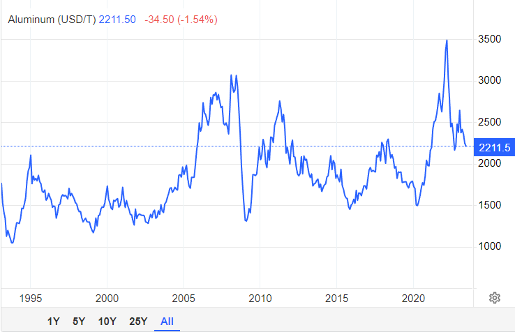
The dam was built as Alcoa produces 2% of the world’s aluminium supply, and global financial markets at the time of construction were expected to make a significant number of jobs, and this aluminium industry was expected to make up 10% of Iceland’s total GDP. This has not happened yet, and the price of aluminium had almost halved just two years after construction finished, and has not recovered to this level seldom for market bubbles seen with the Russian invasion, which stressed productions of almost all raw materials.
 Urban heat island effect
Barrow, Alaska is the northernmost settlement in the USA and the largest native community in the Arctic, with a population of 4600 in 2000, increasing from just 300 in 1900. Recent decades have seen an increase in mean annual and winter air temperature, with an earlier snowmelt in the village and a weaker snowmelt trend in the surrounding tundra. A strong urban heat island (UHI) was found during winter, with the urban area averaging 2.2 °C warmer than the hinterland. There was a strong positive relation between monthly UHI magnitude and natural gas production/use, ultimately resulting in a 9% reduction in accumulated freezing degree days in the urban area. This suggests urbanization has contributed to early snowmelt in the village.
The urban heat island (UHI) effect is a phenomenon where urban areas are significantly warmer than their rural surroundings due to activities by humans, like air conditioning, hot water pipes and road building.
This excess heat is mostly generated from the burning of fossil fuels, the absorption of solar radiation by urban surfaces, and the reduced evaporative cooling from vegetation. As a result of this input imbalance, permafrost can thaw, leading to changes in the landscape and the release of trapped carbon dioxide and methane, which can further contribute to climate change in these areas.
This thawing can furthermore lead to infrastructure damage, as roads and buildings can be damaged by the shifting of the ground.
Case study: Kárahnúkar Dam, Iceland
This dam was build in East Iceland in a large proglacial lake, resulting from one of the largest glacier in Europe. It is actively retreating, so provides water to the dam which can then be used as hydroelectricity. The dam itself was finished in 2007 and is large enough to be seen from space.
The dam could provide enough energy for all Icelandic homes and small businesses, but instead all energy provides the nearby aluminium smelter, Alcoa.
However, there has been widespread backlash over the prokect, as it flodded over 400,000 acres of unspoilt highland wilderness, the second largest unspoiled area in Europe. In total, almost 750,000 acres were affected by the construction of the dam, which is around 3% of Iceland’s total land mass.
The dam was built as Alcoa produces 2% of the world’s aluminium supply, and global financial markets at the time of construction were expected to make a significant number of jobs, and this aluminium industry was expected to make up 10% of Iceland’s total GDP. This has not happened yet, and the price of aluminium had almost halved
Glacial meltwater, or milk, is released by the Vatnajökull glacier and flows into the lake blocked by the dam. This glacial meltwater is known to have high concentration of sediment within it, and as such reduces the capacity of the dam over time. This is because the suspended sediment at the base of the water solidifies when deposited, as there is little kinetic energy at the bottom to keep suspended sediment floating. Over time, the base level of the lake increases, reducing overall water capacity, until this excess sediment is ‘purged’ by the dam management system, which may happen annually.
Here’s a video of sediment getting purged
That’s the end for glaciation! I hope you found it useful.
What if I told you about Paraglaciation and Paraperiglaciation as well?
[TBD] Disease Dilemmas
This will take a while to write up…
[TBD] 2.2.2 Global Systems – Migration
Page 30 in the OCR A Level Geography H481 Specification or search for: ‘Global Systems: Option B – Global Migration’
A migrant is …
Interdependence - interrelationships between ACs, EDCs ans LIDCs through trade, foreign aid and migration
Globalisation - the growing integration and interdependence between peoples’ lives economically, politically and environmentally.
[TBD] 2.1 – Changing Spaces; Making Places
What’s in a place?
Key idea:
1.a. Places are multi-faceted, shaped by shifting flows and connections which change over time.
Content:
Case studies of two contrasting place profiles at a local scale, including:
- their demographic, socio-economic, cultural, political, built and natural characteristics that shape their place identity.
- their past and present connections that shape the place identity and embed them in regional, national, international and global scales
- how shifting flows of people (such as commuter, migration), resources (such as natural, technology), money and investment (such as EU funding, TNCs) and ideas (such as knowledge economy) have helped shape the demographic, socio-economic and cultural profile of these places over time.
A place can be described as a location created by human experiences.
A space, on the other hand, has no added social connections or added perceived values.
For example, a car parking space at a shopping market has no value to you. It’s just a one time location which you leave your car at. However, a parking place at your work may have your name on it, it may be valued by yourself and there may be some memories associated with it, such as tripping over or talking to someone there.
One person’s place may be another’s space.
Places can have different connections and perceptions. These are also likely to change over time. For example, 10 Downing Street may be perceived by characteristics, such as being a centre for political power, socioeconomic decisions or even for Larry the Cat who’s there. It also has many factors which determine how people perceive it, such as the current political affiliation or recent decisions made by the people inside.
Place Identity is a combination of many characteristics that comprise a place. These factors include:
- socioeconomic (housing tenure, employment, income)
- political (national and regional government)
- cultural (religion, traditions, societies)
- physical (altitude, geology, proximity to natural features like rivers)
- demographic (ethnicity, age, gender)
- the built environment (building materials, ages, density)
Places are multi-faceted, shaped by shifting flows and connections which change over time. This can be seen with Canary Wharf, which is now a hub for businesses, bing banks, trade and commerce. It was part of the London Docklands, which became gentrified after the decline of the shipment industry. Flats were demolished and rebranded from old, contaminated stockhouses to new entrepreneurial small businesses and now high-rise, technologically advanced buildings coupled with bars, cafés and waterside views, giving it a sense of identity. To the people who work there or go there regularly, this is a place, not just a space.
Case study: Place Profile - Mancroft Ward, Norwich
A ward is an administrative region of a city or borough, electing its own councillor.
Physical Geography
Norwich is located on the River Wensum, flowing through the city. It is surrounded by many rivers and tributaries like the Yare and Waverley. These rivers have played an important role in the development of the region and city, both for industry and for transport. The geology is mostly composed of sandstone and chalk, used historically in the buildings, being durable. This style has been seen in the castle, while flints are used in many of the churches.
Political
Norwich is governed by Norwich City Council. The city has 39 city councillors, with 13 electoral wards, each having three councillors who undertake casework for constituents, making council policies, budgeting and service delivery. The county council runs education services as well as social care and transport.
Bonus info: the Russell Street Community Area Residents Association is a group of people within the Mancroft Ward who discuss local issues such as litter, tackling homelessness and lonliness, meeting monthly, and using platforms like Facebook to communicate to make the area more pleasant to live in.
May 2022 Council Election Results. Turnout 35.3%
| Candidate Name | Political Party | Votes | Elected |
|---|---|---|---|
| Carrington Jess | Labour and Co-operative Party | 691 | |
| Dean Gordon Richard | Liberal Democrats | 55 | |
| Gwynn Iain Michael Morgan | The Conservative Party Candidate | 243 | |
| Osborn Jamie | The Green Party | 1,606 | X |
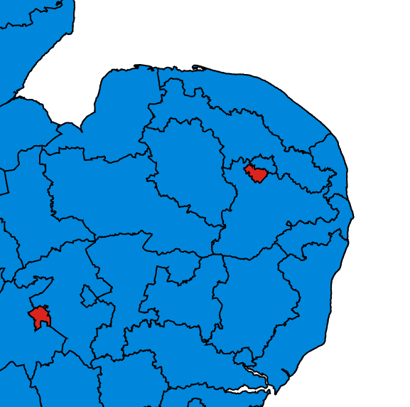
Mancroft is part of Norwich South for general elections. In 2019, it was one of two districts to vote Labour in the East
Built Environment
Mancroft is home to a variety of architectural styles and ages, ranging from the 15th century to the modern day. Examples of 15th century buildings include the Guildhall, whilst 19th century developments include the Royal Arcade. The skyline is generally low-rise. The
The ward also contains two modern, innovative shopping centre developments, Chantry Place and Castle Quarter. Furthermore, The Forum is a modern development in amongst the 499 listed buildings. Very diverse, e.g. Norwich Market with various stalls from tearooms, army equipment, Italian street food to Indian scents and spices - reflecting the diversity of the ward (and city as a whole!) and demands for these foods. The ward’s population density at is also 10 times the UK average, having approximately 5,000 homes.
History
The ward itself is named after St Peter Mancroft alongside the parish church. There are two cathedrals and a castle in the city, one of which is in the ward, which itself is very rare across the UK. The name originated from the Latin term “Magna Crofta”, or “Great Field”. It used to be the second largest and most important city in England before industrialisation occurred. There was a strong trade bond with the Netherlands through the River Wensum, which extends out into the North Sea that allowed for easy boat transport. To this day, some of the city’s walls which surround this area are still in good shape thanks to their listed status such as Cow Tower and Black Tower.
Demography
2021 population:
- 10,618 people. 2.012km2 with 5,252 people per km2.
- Annual population change is 3.2%, from 2011 to 2021.
- There are 10 more males than females at 5,313 men, showing a very even distribution.
- 84.4% white, 6.8% Asian, 3.3% black, mixed race 3.5%
- 77% of the population originated the UK, 23% were foreign born residents, of which 9.9% are from EU countries.
- The highest population in age distribution bracket is 20-29 years, which contains 2,740 people
Least religious city in the UK! with 57.8% saying they have no religious affiliation! Christianity is still the second most popular, and Islam is third at 33.5% and 3.5% respectively.
Socio-economic
Mancroft is categorised as a built-up area alongside most of Norwich by the ONS. Large amounts of flats, apartments in a close proximity suggests that there are many employers and jobs available within the region and city, so employees can easily access these facilities.
11% of the ward are retired and therefore less economically active. There are also 866 students and the most will be paying rent and working, contributing to local economy. There are 5353 economically active people, while there are 2466 economically inactive residents.
Furthermore, the average income is £32,000, showing that there are many professional jobs being occupied. This means that there is a reasonable amount of disposable income for residents to spend on facilities and more recreational activities, such as supporting local cafes which tend to be at a higher price.
The majority of homes have 3-4 rooms, (not just bedrooms), suggesting that the majority of people in the area are either single or in a relationship without children. There are 5708 homes in total, with 3188 people living alone. This data implies that there are many workers living in smaller, urban dwellings. When families are formed, they then go on to move away from the inner city area and potentially to more suburban areas outside of Mancroft.
These statistics reflect the average “life progression”, with people working in inner city jobs or are students during thier early 20s due to work facilities available, nightclubs and nightlife (being more ‘adventurous’), but then settle in a more comfortable job and have families, moving to more remove areas with a larger house to take care of children.
Summary:
Overall, Mancroft is a built-up area with a high population density, suggesting that it contains a large amount of flats and buildings in close proximity. The population is diverse, with 11.07% of the ward being retired, 866 students, 5,353 economically active people aged between 16 and 74, and 2,466 people economically inactive. The majority of homes have 3 or 4 rooms, with an average of 2.51 people per household, suggesting that the area is mainly occupied by single people or very small families. This data implies that Mancroft is a roughly working to lower middle-class area (also inferred by its political affiliation) with many workers living in smaller houses, and families would then go on to move away from this area in the city centre with increased affluency and more likely to be middle-class.
Case study: Place Profile - Sheringham North Ward, North Norfolk
Physical Geography
Sheringham is situated on the North Norfolk coast. One of the highest points in Norfolk is located in western Sheringham, known as the “Beeston Bump” locally. It is 73 metres high and is made up of old glacial moraines dating from the end of the Pleistocene epoch eround 11 to 13,000 years ago, when northern advancing glaciers retreated. It is made out of sand, gravel and stones.
For this reason, and the proximity to the coast, it was used to protect the homes behind it, being less prone to erosion from the sea due to the increased mass to erode. There also used to be two villages behind this bump, which have now merged into one larger conurbation. (It used to be two roughly symmetrical hills that has now merged into one, just like the conurbation!).
The coastal cliffs in the area are made of sedimentary rocks such as chalk, clay and flint, which have provided the region with building materials and is why there are many small cottages or other buildings in the area made of flint.
There’s also a lot of prominent erosional processes and westwards longshore drift, resulting in sandy beaches and the necessity of groynes on the beach to maintain this sand.
Political
Sheringham is part of North Norfolk in general elections. In the 2019 general election, 58.6% of the vote was Conservative (up from the UK average of 43.6%) , which was a gain of 16.9% of the vote since the previous year’s election.
The Labour Party made up just 7.7% (compared to 32.1% in the UK) and the Lib Dems made up the second largest party at 30.3%, with a respective decline of 2.2% and 18.1%. 58.9% of North Norfolk, which included Sheringham, voted to leave the European Union in 2016. The MP, Duncan Baker, was a member of the UKIP party before the Brexit campaign.
Built Env
Flint is the most common and naturally abundant material in Norfolk, particularly for the building of cottages. This is especially pronounced in coastal areas such as in Sheringham North Ward. It is also an iconic material for tourism, as well as typically costing more to use than bricks and also looking good on postcards!
History
It was ‘created’ in 1086. The land was owned by William d’Ecouis. The Domesday entry lists public land, slaves, farm animals, churches and more in modern-day Sheringham.
In the late 1800s it was a major crab and lobster fishing centre and supplied London markets using new railway routes brought about from industrialisation from the 200+ fishing boats and companies which regularly went out from the port at this time. Many large business owners who had lots of money to spend, especially during the industrialisation period, bought large mansions or constructed their own buildings in the area, which created a snowball effect with other businessmen
It continued to be popular for particularly more wealthy and affluent people as holidays throughout the 20th century. From the 1950s and up onwards it has continued to attract elderly people for retirement due to its peaceful and serene atmosphere as well as having good coastal views and sufficient amenities.
Demography
In Sheringham North, the population in 2021 during the last census was 2,470. 98.1% of the population were white British. There were only four black residents.
The highest population age distribution bracket was between the 70 and 79 years age range with 464 people. Furthermore, 39.4% of the entire population are aged above 65. Just over half, at 50.8%, are between 15 and 64 years old. Of this total, 95% come from the UK.
The population has actually decreased from 3002 in 2011.
Socio-economic
In Sheringham North, there are 622 households with one person with a serious health condition, meaning that they cannot work. There are 64.7% of men who are economically active, compared to 59.6% of women economically active, meaning that 35 and 40% of them are inactive in the economy, respectively. 29.66% of people are managers, directors or senior officials and in professional occupations.
This shows that there may be an upcoming problem for the council and town planners as these older people continue to age, more accessible features will have to be put in place to support them.
Average costs for a terraced house are £223,500 to £312,500. For a semi-detached house, this is £250,000 to £364,500. A detached house costs typically over over £400,000.
Comparisons
Sheringham has a much older demographic with an average age of 51 years compared to 37 in Mancroft. This may result in more services like bingos and buses, with less schooling in Sheringham. Sheringham may also be less reluctant to change, not only because of the older population who are typically less accepting of new ideas and visions, but the people living there may spend more time retired compared to the lower, younger, more accepting population like students who may only spend 2-3 years in the area, who may be less inclined to travel further away to places such as Cromer to get their shopping done as they do not have as much time as the older, retired population.
[Dev Note 3/6/23] Possibly add more comparistions and their impacts on place identity here.
Shifting flows of money, investment and ideas on place identity
Norwich first started as a Saxon marketplace in the 800s and 900s, exporting wool. Throughout the Middle Ages, it was England’s second largest city.
During the Industrial Revolution, there was a large amount of rural to urban migration who powered new industries such as the mustard and chocolate factories.
It became a centre for textiles and shoemaking until the early 1900s. The ex-largest insurance company, Aviva, or Norwich Union, was established in the 16th century and then proceeded to go global.
It was relatively isolated until the railway arrived in 1846. It was faster to go to Amsterdam by boat than travel to London.
Since then, it has had a complete revolution. Norwich is now the eighth most prosperous shopping location in the UK, with old-fashioned industrial buildings and factories being redeveloped and gentrified into new places such as Riverside, Castle Quarter, and Chantry Place.
There has been a constant flow of students and academics in the area, fuelled by the UEA, which has close connections to world-renowned Cambridge Universities. The UEA also houses the John Innes Centre, which has provided global breakthroughs in the fields of biology and sciences, and Tyndall Centre for Climate Change, equally as significant. This has transformed the economy into a quaternary knowledge economy, supporting high-tech and scientific quaternary sector jobs, comparing to around 250 years ago, when it was just primary and secondary sector hub, involving large amounts of manufacturing and farm labour.
Norwich is a commuter town too, with people coming into work from surrounding villages, and good transport links with goods moved into Norfolk via the M11 and A14. This has continued to attract investment by transnational corporations.
Shifting flows of people
At the heart of it, people are what turn a space into a multifaceted place. The exact stage in people’s lives determine and influence where people live. For example, the location and housing tenureand house type, and by extent, the place profile.
The local availability of a resource or natural advantage can encourage the growth of a settlement and mould its identity by fuelling industry. If these resources run out or global shift occurs for a particular product, technology typically takes over the natural advantage and the place profile can and often change. In Norwich for example it has become cheaper and easier to manufacture goods like shoes and chocolate overseas and import it thanks to globalisation leading to the replacement of local resources. Ocean going ships have grown significantly in size and can no longer fit up the River Yare so the riverside docklands fell into decline, much like the London Docklands.
How do we understand place?
Key Ideas
a) People see, experience and understand place in different ways, this can also change over time.
b) Places are represented through a variety of contrasting formal and informal agencies.
Content A:
- The complexities that exist when trying to define place, including the concept of space versus place.
- How and why people perceive places in different ways based on their identity, including age, gender, sexuality, religion and role.
- How level of emotional attachment to place can influence people’s behaviour and activities in a place.
- How the processes of globalisation and time-space compression can influence our sense of place.
Content B:
- How informal representations of a place differ through contrasting media such as TV, film, music, art, photography, literature, graffiti and blogs.
- Identify how formal and statistical representations of a place, such as census and geospatial data, contrasts with informal representations.
Place Perception: Uluru and Jerusalem
Emotional attachment: The Kurds and Kurdistan
Globalisation and our sense of place
Economic change and patterns of social inequality
Specification content:
3. How does economic change influence patterns of social inequality in places?
3.a. The distribution of resources, wealth and opportunities are not evenly spread within and between places.
- The concept of social inequality and how this can be measured through indices such as housing, healthcare, education, employment and access to services.
- How and why spatial patterns of social inequalities vary both within and between places.
3.b. Processes of economic change can create opportunities for some while creating and exacerbating social inequality for others.
- The influence of global connections and globalisation in driving structural economic change in places, such as de-industrialisation and the rise of the service industry.
- How structural economic change impacts patterns of social opportunities and inequality for people and places.
- How cyclical economic change (booms and recessions) has varied impacts on social opportunities and inequality.
- The role of government in reducing, reinforcing and creating patterns of social inequality in places through spending or cuts in key services such as availability and accessibility of education, healthcare, infrastructure and community services.
3.c. Social inequality impacts people and places in different ways.
- Case studies of two contrasting places to illustrate:
- the types of evidence of social inequality that can be found there such as housing, environmental quality, crime rates, digital divide
- the range of factors that influence people’s social inequality such as income, gender, age, health, personal mobility, ethnicity and education
- how social inequality impacts upon people’s daily lives in different ways.
[TBD] Measuring Social Inequality
Book reference: pages 158-162
The Gini coefficient is used to measure the inequality of income and thereby deprivation within countries. Here is the UK stats on the ONS website.
Players that impact on economic change
Specification content:
4. Who are the players that influence economic change in places?
4.a. Places are influenced by a range of players operating at different scales.
- The role of players in driving economic change, including at least one of local and national government, MNCs or international institutions.
- Case study of one country or region that has been impacted by structural economic change, including:
- socio-economic, demographic, cultural and environmental characteristics of the place before the economic change
- the economic change/changes that took place and the role of players involved in driving the change
- socio-economic, demographic, cultural and environmental impacts on people and place.
Placemaking processes
Specification content:
5. How are places created through placemaking processes?
5.a. Place is produced in a variety of ways at different scales.
- The concept of placemaking and how governments and organisations attempt to present places to the wider world to attract inward investment and regeneration.
- How architects and planners attempt to create meaningful and authentic places through design, such as places that encourage mixed community use or the 24 hour city.
- How local community groups shape the place they live, such as residents associations, heritage associations and social media
5.b. The placemaking process of rebranding constructs a different place meaning through reimaging and regeneration.
- Why places rebrand through reimaging and regeneration to construct a different place meaning.
- How a range of strategies can be used to rebrand places, such as sport, art, heritage, retail, architecture and food. These can be used singularly or in conjunction to change a place meaning.
- A range of players and their role in placemaking, including government/EU funding, corporate bodies, not for profit organisations and community groups.
- How and why some groups of people contest efforts to rebrand a place.
5.c. Making a successful place requires planning and design.
- Case study of one place that has undergone rebranding, including:
- why the place needed to rebrand
- strategy/strategies involved in the rebranding of the place
- the role and influence of a range of players involved in the placemaking
- how the rebranding has altered people’s perception of that place
- the relative success of the rebranding.
Rebranding
There are 5 main ways to rebrand an area:
- Top-down investment
- Market-let strategies
- Flagship developments
- Events
- Legacy
(Others include art events, historical exhibitions etc.)
end of paper 2
NEA stuff
Spearman’s Rank
In the first sheet, in cell E5, you write:
=RANK.AVG(C5,$C$5:$C$24,0)
This compares the value of the cell in C5 to those in cells 5 to 24.
You then go to the bottom right of the cell and drag the dot to cell E24
This will copy that earlier formula to give the results for each row. This is because we need the results in an ordered format.
Repeat this for the Cancer rate column (so =RANK.AVG(D5,$D$5:$D$24,0)) in column F
Finally, in any other cell, we can use the cool excel CORREL function to just work it out
=CORREL(E5:E24,F5:F24)
This gets the spearman’s correlation for the two sets of data
Footnotes
(Disclaimer) AI-assisted writing
ChatGPT or any other text-based generative transformer model was not used to directly write the content here. It’s good for clarification of certain topics (and I’ve used it for that), but don’t get used to it otherwise you’ll lose your creativity.